
The Hike of a Lifetime: Aspen to Crested Butte
By car, Crested Butte and Aspen are 100-plus miles apart. But if you're in search of adventure, the two mountain towns are within walking distance—sort of. A popular 11-mile trail from Aspen to Crested Butte takes hikers over the 12,500-foot West Maroon Pass and is one of the most iconic routes in the area. Here’s the low-down on hiking between two of Colorado’s favorite ski towns.
The trailhead starts at Maroon Lake and the entrance to the Maroon Bells-Snowmass Wilderness Area. Due to the recent surge in visitor numbers, reservations are now required to access the area, whether you arrive by car or bus.
Getting to the Trailhead
The Aspen to Crested Butte hike begins at Maroon Lake and the entrance to the Maroon Bells-Snowmass Wilderness Area. Due to the recent surge in visitor numbers, reservations are now required to access the area, whether you arrive by car or bus. (If you want to add a second sport to your adventure, biking the 10 miles up Maroon Creek Road can be done anytime.)
By Car
Parking reservations ($10/vehicle) are required May 15 through October 31. For Maroon Bells reservation questions, visit the reservation site, call 970-930-6442 or email info@visitmaroonbells.com. These reservations include a two-night option for overnight hikers, but note that even with this reservation, cars cannot access the road between 8am and 5pm, which means you'll need to plan to arrive at the trailhead early.
By Bus
If you opt for the bus, the shuttle ($16/adults, $10/seniors 65+ and children 12-) starts running 8am from Aspen Highlands. The last outgoing shuttle departs at 3pm and the last return shuttle departs Maroon Lake at 5pm.
By Drop-Off
Private vehicles can drop off passengers between 6 and 8am without a parking reservation, but visitors who are dropped off during this time will need a one-way ticket ($16) to ride the shuttle down to Aspen Highlands after 8am. Commercial drop-offs are not allowed at any time.
Note: There are a number of limited, day-of tickets released after no-show reservations. Prices are higher and tickets aren’t guaranteed, so this option is best for those who aren’t on a tight schedule.
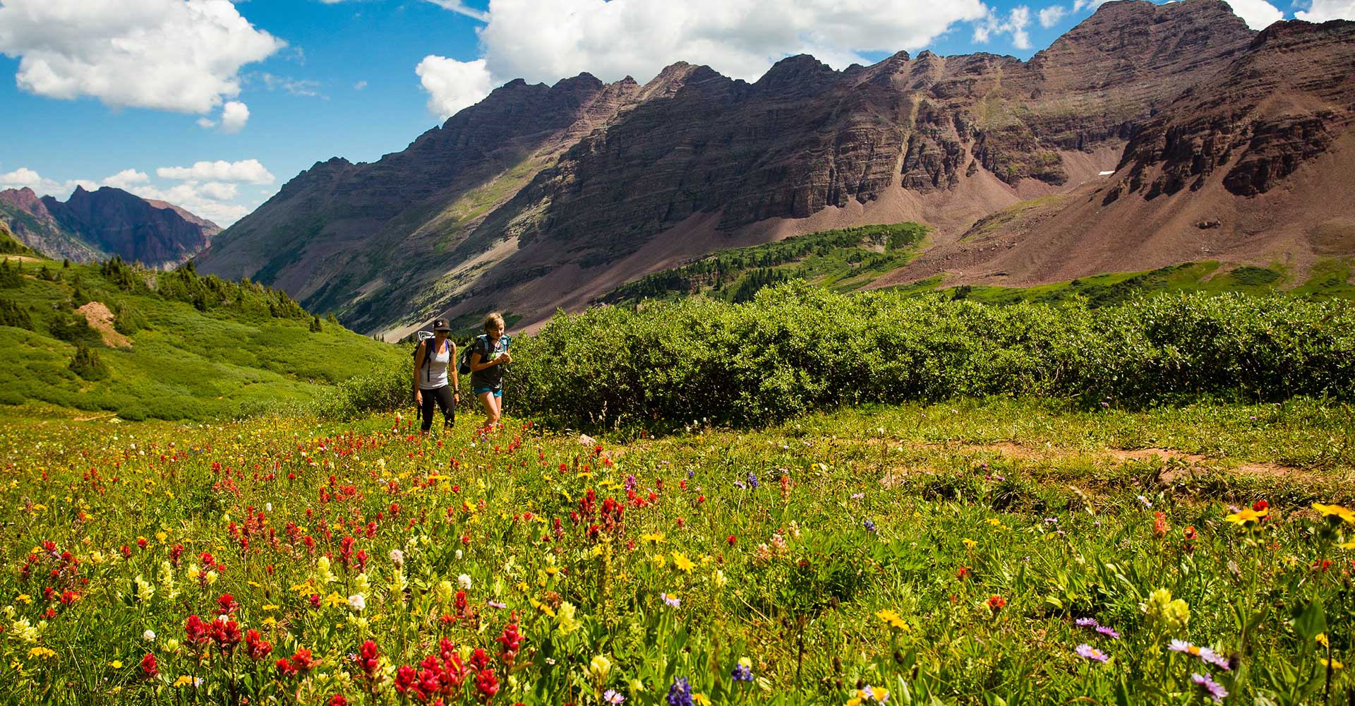
Wildflowers galore en route from Aspen to Crested Butte
Aspen to Crested Butte Hike Difficulty and Elevation Gain
It’s not just the cool factor—linking two mountain towns—that makes this hike unique. It’s also breathtaking. As the US Forest Service notes: “The Elk Range runs from northwest to southeast between the two towns, with seven 14, 000-foot peaks and several thirteenersreaching to the sky and creating a formidable barrier. The rugged terrain serves a purpose, however, intimidating the casual day hiker and providing a safe haven for a variety of wildlife.”
The hike begins at 9,580 feet above sea level at Maroon Lake. From there, it climbs 3,000 feet over seven miles to West Maroon Pass before descending another four miles into the East Fork of the Crystal River drainage below Schofield Pass.
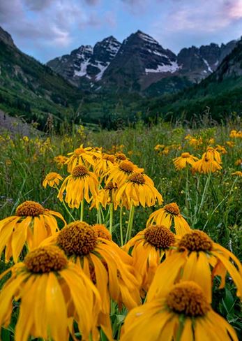
Wildflowers on the Aspen to Crested Butte Trail
The first 1.8 miles to Crater Lake climb through giant aspen groves. Because this part of the wilderness area provides access points to many of the surrounding 14ers and different trails, like Buckskin Pass, it can be crowded. Once past Crater Lake, however, crowds dissipate and the long yet moderate climb up West Maroon Creek is stunning. The trail meanders along the creek before popping into high alpine tundra above the tree-line. Depending on the time of year, there are some stream crossings which can require wading through chilly runoff water.
The ascent to West Maroon Pass is known for some of the most bountiful and colorful wildflowers in the area, especially from mid-July into August. The last mile to the pass is a set of steep switchbacks, but the view at the top is a worthy reward. Try to get here before noon to enjoy lunch with a view, avoid afternoon thunderstorms, and meet your shuttle in time (more on that shortly).
The descending four miles weave down into a wide-open valley that looks more like the Swiss Alps than Colorado backcountry. About one mile from the pass, the trail intersects with Frigid Air Pass. Continue straight, as Frigid Air will continue along the Four Pass Loop. Eventually the trail will pass an old cabin and shortly after, spits hikers out at the West Maroon trailhead on the Crested Butte side. Make note: Here, you’re still 11 miles from the town of Crested Butte, and the best way to get the rest of the way there is to book a shuttle. The two options are Dolly’s ($55/person or dog with a $220 minimum) and Alpine Express.
Best Time of Year to Hike from Aspen to Crested Butte
What to Pack for the Aspen to Crested Butte Hike
Waterproof hiking shoes or trail runners
Layers for changing weather
Rain jacket
Snacks and plenty of water
Trekking poles for stream crossings and steep sections
Bear-proof food container for overnight trips
Getting Back
If you’re not hiked out, return over East Maroon Pass for some extra miles. This less-crowded, 16-mile trail starts on Gothic Road from Crested Butte, and the trailhead is located at the Copper Creek lot. The trail climbs a double road to Copper Lake (there are several stream crossings here) and eventually to East Maroon Pass. From there, it drops into the East Maroon Creek Valley, meandering for 10.5 miles back to Maroon Creek Road where hikers can pick up the bus.
Quick Tips for the Hike
Thunderstorms
Plan hikes early in the day to avoid afternoon thunderstorms. Remember to pack appropriately and be prepared for all conditions and events.
Leave No Trace
Don’t leave anything behind. This is a fragile high alpine ecosystem and is already suffering because of overuse. Pack out all trash, and bury human waste 6–8 inches deep and at least 100 feet away from the trail.
Dogs
Dogs are permitted but must be leashed, and you must carry out all dog waste. This is a strenuous hike and should only be attempted dogs (and people!) with backpacking experience.
Bears
Bear activity is common in this area. Certified bear-proof containers are required for overnight trips, so be sure all your food, drinks, and cooking utensils fit in your canister before you depart.
Stream and Snowfield Crossings
Stream crossings can be dangerous during runoff periods. Consider bringing waterproof shoes to cross streams and make sure to unbuckle your pack so it won’t weigh you down if you fall. Depending on how early in the season you're hiking, there can also be snowfields to cross, so be prepared if you feel you’ll need hiking poles or microspikes for your boots or running shoes.
You can check trail conditions and recent reviews on sites like AllTrails to be prepared.
This is not an official trip guide. Please visit the U.S. Forest Service website or office for thorough trail descriptions, and remember to pack a map and directional tools as well.

