Whether or not there are cars on the road, though, pedaling Independence Pass is no joke. Cyclists need to approach this route with prior fitness, and comfort handling steep downgrades (especially during summer, when vehicle traffic is high). If you check those boxes, the ride proves to be quite a reward, climbing 4,144 vertical feet and 19.5 miles to the top.

Cycling Guide to Biking Independence Pass
A ribbon of road through aspen and pine, topping out at 12,095 feet—Independence Pass is one of the most scenic routes in the world and one of the best bike rides you'll find cycling in Colorado. Here is everything you need to know before tackling one of Colorado's most epic routes on two wheels.
For the best possible experience, hit the road in early spring once the snow melts, but before cars are allowed on the road, usually around Memorial Day.
By Spencer Miller, updated May 2025
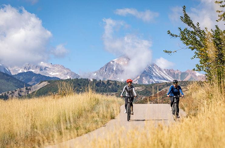
Independence Pass near Aspen goes over Colorado's Continental Divide and drops down into Twin Lakes, just outside Buena Vista. The only thing better than driving it is being able to look around, with your head in the clouds, spinning on a bike towards the top. Summer allows for warm weather and wildflowers, but every local's preferred window to cycle the Pass is during the late spring, once the snow has melted off, and before the road opens to cars sometime around Memorial Day Weekend. During that time, it’s described as a “pure” experience—everyone you’ll see along the way has truly earned it, and the only sound comes from the whirring of your chain.
Biking Independence Pass
4,144 feet in 19.5 miles

Three cyclist ride by the camera on Independence pass in Aspen Colorado, past a green field and stark, Rocky Mountains in the background
The uphill grade averages 4%, with a few 7% sections thrown in for good measure—one midway, and one just a few miles from the finish. Plan for two to three hours to get up, and around an hour to get back down. It’s a very steady, slow burn, but doable if you have the time and motivation.
How to Prepare for Your Independence Pass Ride
Bike & Gear Prep

- Check all your bolts. You surely don’t want anything rattling loose on the way down.
- Make sure those brake pads have enough life left in them. This isn’t the place to find out you’re scraping rim or disc.
- Prepare for a flat and bring a spare tube, unless you’d like to walk (or hitchhike).
- You’ll definitely work up a sweat on the uphill, but the summit tends to be much colder and windier than where you started from. Pack a light shell, and check the weather forecast for rain—storms approach quickly above the tree line.
How to Ride the Pass

- Park in town, and start heading east on Cooper Avenue. This will eventually turn into Highway 82, which leads all the way up. No need to worry about getting lost.
- Generally, riding the Pass is safest with a small group. It gives you better visibility (and people to steal snacks from). Stay single-file, and during summer, keep an eye out for cars. Cyclists do have the right of way, but not every vehicle tends to agree.
- When the road opens to motorized vehicles, it’s best to avoid peak travel times, as cars are traveling both to and from Aspen. Weekends and afternoons are surely busier than mornings and mid-week ventures.
- For the best possible experience, hit the road in early spring once the snow melts, and before Memorial Day, when cars join the party.
Once you make it up, snap a summit selfie for Strava, have a snack, and get ready for one of Colorado’s most classic descents. You earned it.

Enhance Your Road Ride
Forget your road bike on your trip to Aspen? Or maybe you just want to try a new ride up Independence Pass. Aspen Collection to rentals offers top-tier carbon bikes tailored for your road adventure.
Independence Pass FAQs
Where is Independence Pass?
Independence Pass is located on Highway 82 between Aspen, Colorado and Twin Lakes, near Buena Vista. The pass crosses the Continental Divide at an elevation of 12,095 feet, making it one of the highest paved roads in the United States.
When does Independence Pass open?
Independence Pass typically opens to vehicle traffic around Memorial Day Weekend, depending on snowpack and road conditions each year. The window before cars are allowed—usually from when the snow melts through late May—is the ideal time for cyclists to ride the pass without vehicle traffic. Check independencepass.org for the most current opening information.
Is Independence Pass open?
Road status changes each season based on weather and snowpack. Visit independencepass.org for real-time road conditions and the latest opening dates before you head out.