Cross-Country Skiing

Enjoy one of the largest free groomed cross-country ski systems in North America.
The Aspen Snowmass Nordic Trail System boasts more than 60 miles of free cross-country ski and snowshoe trails that connect the communities of Aspen, Snowmass and Basalt. Trails are varied in terrain for beginners to experts. Beautiful vistas, great exercise and outdoor fun for the whole family.
Visit Aspen Nordic's website to view trail reports and conditions.
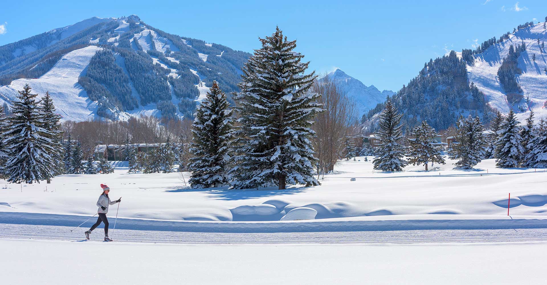
A woman enjoys Nordic skiing at Aspen with Pyramid Peak in the distance.
Cross-Country Skiing Trails In Aspen Snowmass
Browse local cross-country skiing and snowshoe trails below.
Town of Snowmass Village Cross Country Rental
The Town of Snowmass Village and Snowmass Village Recreation Center provide a variety of rental equipment for you Cross-Country experience. Call 970-922-2240 to get more information.
Village Way
Village Way is an access route between Snowmass Village and the Snowmass Golf Course tracks. The trail is fairly steep, making the route somewhat challenging in either direction. Dogs are allowed.Difficulty: Intermediate
Length: 2 miles
Access: From Snowmass Village, this is best reached from the bottom of the Assay Hill Lift. From the golf course, follow the same direction as the Owl Creek Trail but turn right after Owl Creek Rd.
The Terminator
The Terminator, which loops around the Two Creeks development, is an exciting trail for advanced cross-country skiers. This loop can also be used to access the Owl Creek Trail.Difficulty: Advanced
Length: 3 miles for the loop
Access: Follow the same direction as the Owl Creek Trail but continue straight uphill after crossing Owl Creek Rd. Be aware and yield to downhill skiers.
Owl Creek
This popular and scenic trail connects Aspen and Snowmass Village, hugging the south side of the Roaring Fork and Owl Creek valleys. Most skiers use this trail as a casual tour with a lunch break and light touring gear. The easiest and most popular stretch of trail runs from the West Buttermilk Road to the Snowmass Cross-Country Center. Another popular option from West Buttermilk Rd. is to ski to Sinclair Divide and back. The new Tiehack Nordic Bridge will allow skiers easy access to the Owl Creek Trail from the Aspen Cross-Country Center. Follow the green disks to stay on course when crossing the Buttermilk Ski Area. Be aware and yield to downhill skiers.Difficulty: Intermediate; most of the trail is good for beginners, but the occasional hills add some difficulty. East of Tiehack, the trail is for advanced skiers only
Length: 9 miles from the Aspen Golf Course to the Snowmass Cross-Country Center
Access:
- Snowmass Village: Village Way Trail or Snowmass Cross-Country Center. Follow signs.
- West Buttermilk Road: Drive through the Main Buttermilk parking lot from Highway 82 to West Buttermilk Road at the far right corner of the lot. The Owl Creek Trail crosses 1.4 miles up the road, by a small parking area on the right.
- Tiehack: Experienced skiers can ski from the base of Tiehack up along the right side of the alpine trail to the Oregon Trail towards and across Main Buttermilk. Follow the green disks.
- Aspen Golf Course: Access Tiehack via the James E. Moore Trail and the new Tiehack Nordic Bridge
Aspen Golf Course and Cross Country Center
The Aspen Cross-Country Center is located at the Aspen Golf Course, 1 mile west of Aspen off Highway 82. The Center offers ski lessons, tours, retail shop, rentals, a lounge, lockers, snacks, and videos. The Aspen Golf Course and the Snowmass X-C center are the first areas to be groomed after heavy snow.Difficulty: Beginner
Length: 2.5 miles
Access: Free bus service available. Moore, Marolt and High School trails are all easily accessible from the golf course trails
James E Moore Trail
The James E. Moore Trail has a short loop and a connecting trail to the the High School, Iselin and Owl Creek trails. The loop is entertaining because of its fun, winding hills. Both the flat connecting trail and loop wind through open sage areas that are home to deer, fox and other wildlife.Difficulty: Beginner and intermediate
Length: 2 miles
Access: The safest access is via the roundabout pedestrian underpass. Or, from the parking lot at the Aspen Golf Course, cross under Highway 82 on foot and go 200 feet to the left (east). Free bus service available.
Bernese Boulevard
Located on the Aspen Golf Course, the Bernese Boulevard provides dog owners and their pets a scenic route around the perimeter of the golf course. Please keep your pet under control at all times.Difficulty: Beginner
Length: 2 miles
Access: Free bus service available
Marolt Property Tracks
These tracks are used primarily as an access route between the west end of Aspen and the Aspen Golf Course and the High School tracks. Dogs are allowed.Difficulty: Beginner
Length: 1.5 miles
Access: From Aspen, by foot, take Hopkins west to 7th Street and go left, then turn right at the Marolt Pedestrian Bridge
Maroon Creek Trails
These tracks are accessed from the Tiehack Nordic Bridge or from the Buttermilk base area. Adventurous skiers can also reach these trails from the Aspen Golf Course by way of the Maroon Creek Trail. This scenic section of track can sometimes be short of snow and has steep turns and terrain and is for advanced skiers only.Difficulty: Intermediate. The connection with the Aspen Golf Course has steep turns and terrain and is for advanced skiers only
Length: 2 miles on and around the golf course
Access: Pick up the tracks beyond the Panda Peak lift at the Buttermilk Base area. Free bus service available.
Rio Grande Trail
A popular walking, skiing and snowshoeing trail, the Rio Grande follows the old Denver and Rio Grande Railroad bed along the Roaring Fork River. The mostly flat trail gently meanders through the quiet woods and open sage areas. Because this trail is easy, marked and not groomed, it offers the opportunity to have an adventure in a more primitive setting. Note: the snow can deteriorate quickly on this trail. The Rio Grand is a Dog Friendly trail. Dog owners are required to keep their companion on a leash and to pick up after their pet.Difficulty: Beginner
Length: Up to 20 miles one way, from Aspen to Basalt
Access: The eastern end starts behind the Aspen Post Office. Call for more information as to other access points. Free bus service available.
North Star Nature Preserve Loop
The Preserve is 175 acres of land east of Aspen that has been preserved to allow its natural ecology to continue with a minimum of human impact. Cross-country skiing and snowshoeing are one of the few uses permitted on its flat, open meadows close to the Roaring Fork River. Please stay on marked trails and respect the wildlife. Note: grooming on this trail is scheduled on an as-needed basis only so as to minimize impact.Difficulty: Beginner
Length: A little over 1.5 miles
Access: Go 1.5 miles east of Aspen on Highway 82 and look for the small parking area on the right
Benedict Trail
Benedict Trail This section of trail serves as a connection from the East end of Aspen to the North Star Nature Preserve. It is narrow, winding and mostly in the trees. A small portion of the trail is subject to avalanche danger.Difficulty: Intermediate. Skating not recommended
Length: 1.5 miles from Ute Avenue to North Star Nature Preserve
Access: Follow Ute Avenue to the Ute Trail parking lot, then up a public access 100 yards to where the trail crosses. Free bus service available.